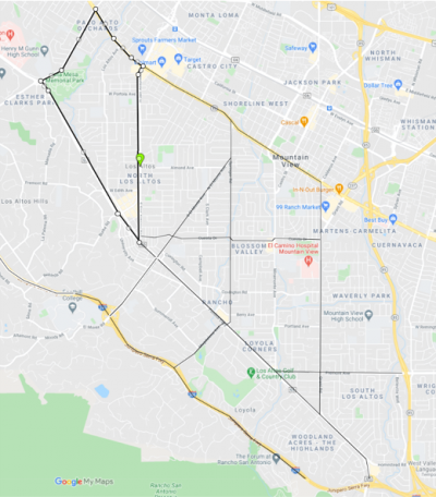
Los Altos Evacuation Routes
Now is the perfect time to study a map of Los Altos and make an evacuation plan for your household
- Identify at least two routes out of your neighborhood,
- Then, identify two more that you could use if those routes were blocked, or were reserved for emergency vehicles.
- Consider where you could go: Stay with family? A friend’s house? A hotel? What about somewhere outside of the Bay Area?
- If you have pets—plan how you would evacuate your pets with you, and understand which destinations are “pet-friendly” (Note: Some hotel chains welcome dogs only, some welcome dogs and cats, and some specify no pets).
Evacuating Los Altos
The City of Los Altos lies within the northwest portion of Santa Clara County. Because the area to the west of the City is rather forested and mountainous in nature, it presents difficulties for first responders in accessing, gaining control of, and managing large wildland interface fires. In addition, the potential exists in Los Altos for severe winter storms, hazardous material incidents, floods, etc. The nearby grasslands; steep terrain; fuel load; dry conditions; winds; low humidity—these increase the wildfire risk for our area. Fire and sparks can travel with the wind, and do not follow city limits. Even a small fire, if not detected early and quickly suppressed, can rapidly turn catastrophic for the City of Los Altos.
The City of Los Altos has developed a City Emergency Evacuation Plan to increase preparedness, facilitate rapid evacuation of the populace, and reduce response times. This plan focuses on evacuations due to wildland interface fires, but much of its application can be made to other natural or man-made disasters.
Evacuation Routes
The primary North/South evacuation routes will include Arastradero Road, West Fremont Road, San Antonio Road, South El Monte Avenue, Magdalena Avenue, South Springer Road, and Grant Road.
The primary East/West evacuation routes from the City will include Foothill Expressway, El Camino Real, Cuesta Drive, Fremont Avenue, Interstate 280, and Highway 101.
Depending on the exact location of the fire or incident and the current damage, the Incident Commander will designate which surface streets are best used for evacuation and which are best for emergency vehicles and how those roads feed into the major evacuation.
Emergency Public Information
The public information officers from the Los Altos Police Department, Santa Clara County Fire Department and other agencies will coordinate issuing advisories, warnings, traffic updates, press releases, and other emergency information.
Subscribe . Like . Follow . Listen: You decide how you want to receive alerts and information about Los Altos
- Click here to learn more about our social media channels
- Resilient Los Altos is one stop for all your preparedness needs
- Emergency Preparedness Pre-Recorded Webinars
- NIXLE community alert messaging (register by texting your zip code to 888-777)
- AlertSCC is Santa Clara County's emergency alert notification system
- Local radio and television stations, including KFJC 89.7FM in Los Altos Hills
Evacuation
Los Altos Police Department will carry out an evacuation order, with assistance from other law enforcement Mutual Aid.
- Individuals refusing to evacuate their homes or businesses will be allowed to remain and will not be forcibly removed.
- Family, friends and neighbors will be encouraged to assist those requiring assistance (medically fragile, aged, etc.)
- Evacuation Warning: be ready to go
- If you feel uncomfortable or have concerns about your safety: leave now. Better to leave early than wait too long to leave.
- Evacuation Order: leave now
- Everyone including anyone who will need extra time to evacuate should go now—medically fragile, those with mobility issues, and those with difficult roadway access.
Please visit www.losaltosca.gov/emergencyprep to learn more about household emergency preparedness, family communication plans, emergency supplies, and preparing a “Go Bag”.

